



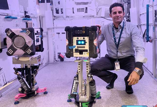
From the suburbs of Brisbane to the International Space Station, an innovative Australian device embarks on a journey to transform how we understand space environments
In the early hours of 22 March 2024, a rocket blasted off from the Cape Canaveral Space Force Station in Florida, USA. On board was a small device labelled ‘Multi-resolution scanning’, packed with CSIRO smarts.
Its goal was to test a new CSIRO-developed 3D sensing and mapping payload for a NASA robot called Astrobee, which operates inside the International Space Station (ISS). Leading the project was Dr Marc Elmouttie. For Elmouttie, this launch was the culmination of years of hard work and extensive international collaboration.
But we’re getting ahead of ourselves. Let’s take a step back. What is the Astrobee anyway? Why does it need multi-resolution scanning? And what are they doing up in space?
Let’s start with Astrobee.
This system of three free-flying robots moves around the ISS autonomously, or via remote control, to document experiments or even move cargo. As modular platforms, they can be loaded with other technologies, one of which will be multi-resolution scanning.
The multi-resolution scanning device brings together two pieces of CSIRO tech: Stereo-Depth Fusion and Wildcat Simultaneous Localisation and Mapping.
The CSIRO-designed payload consists of an array of sensors arranged in a special way – two cameras, three time-of-flight sensors and an inertial measurement unit. You can think of this as the ‘body’. The ‘brains’ consist of the onboard computer running the algorithms. They process the data coming from these sensors to generate 3D maps. They also track the motion of the robot through the ISS by plotting its trajectory.
It’s designed to slot into the Astrobee robot platform and roam the station, creating detailed internal maps.
Elmouttie said integrating these two technologies makes for significantly more accurate data. These high-resolution maps of the ISS be used to demonstrate how multi-resolution scanning technology would work.
The team’s goal is to showcase that the device will produce reliable data to support various uses. This includes real-time localisation of robots, robot-astronaut interactions, or monitoring and tracking inventory including equipment, science experiments, and hull damage from micrometeoroids.
The value of these tasks lies in their potential to significantly enhance operational efficiency and safety aboard spacecraft. For instance, by ensuring precise robot positioning, crew members can better coordinate tasks and interactions.
Meanwhile, monitoring for hull damage could enable proactive maintenance and reduces the risk of critical breaches caused by micrometeoroids.
Subterranean beginnings
Stereo-Depth Fuson and Wildcat SLAM were not originally developed for spaceflight. They were actually created for use about as far away from space as you can get – in underground mining and other terrestrial applications. “There are a lot of hazards inside a mine site. It’s important to understand what the rock is doing and where potentially dangerous objects are within that space,” Dr. Elmouttie said.
“In a lot of ways, these challenges are similar to the space environment, with potential hazards, small spaces, and a need for high-accuracy data.” Wildcat SLAM won the most accurate object detection prize in the DARPA Subterranean Challenge, a global robotics competition for underground exploration.
This smart tech could have simply stayed underground but for a chance conversation. “We’ve been collaborating with Boeing on 3D imaging for a number of years. After one of our project reviews, we received a call asking, ‘could you do this on the ISS?’” Elmouttie said.
“That request initiated a number of meetings between us and Boeing to flesh out the concept of operations for interior space vehicle operations, exterior space vehicle scanning and even off-world roving.”
How do you build a payload?
Once the goal of spaceflight was locked in, Elmouttie brought together a multi-disciplinary team to prepare the payload for the ISS. He pitched a very different proposition to the technology’s previous use case. The team needed to make sure the device could survive the stress of launch and handle the unique environment of the ISS.
“There’s been a lot of iteration involved because we’ve been trying to work to a lot of different constraints,” said Lauren Hanson, Senior Mechanical Engineer for the project. “We’ve got to handle the vibration window of the launch vehicle – that’s the harshest environment we’ll see. We’ve [also] got to choose our materials really carefully,” she said.
After months of hard work, the payload was hand-delivered to the NASA Ames Research Centre in Silicon Valley, California. Here, it would undergo the final phase of testing and certification.
At the end of January, the team finally got the word – multi-resolution scanning had passed all of NASA’s safety checks. Elmouttie and another team member Dave Haddon, travelled to Florida to see the launch up close.
“Knowing that our precious payload, the product of several years of effort from an amazing team across CSIRO, Boeing and NASA, was en route to the ISS made it quite an emotional experience,” Elmouttie said. “Just so grateful Dave Haddon and I got a chance to witness this live!”
With the payload safely on board the ISS, our team now waits for the device to enter the experiment schedule. It will begin by mapping Japan’s experimental Kibō module, with the potential to map the rest of the station afterwards.
“At this point, it’s out of our hands. We’ve done everything we can,” Marc said.
He and the team are waiting for the first on-orbit mission to be scheduled. It will be designed to test and validate their technology in the unique conditions of space.
“The astronauts will pair our payload to the robot and we’ll wake it up. Then flying and scanning can begin!” Elmouttie said.